1. Ariel Castro's house, Ohio:
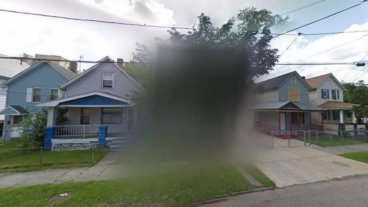
Image source: Reddit
Ariel Castro's house gained notoriety due to the criminal activities that took place there. Castro was a kidnapper and held three women captive in his house on Seymour Avenue in Cleveland, Ohio, for about a decade before they were rescued in 2013. The house became a crime scene and was subsequently demolished.
2. Jeanette Island, Russia:
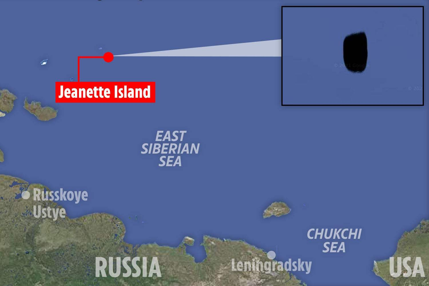
Image source: Reddit
Upon entering 'Jeannette Island Russia' into the Google Maps search bar, users will encounter a notable absence of information on both map and satellite views. The location appears as a blank space, accompanied by a popup message stating that the island is 'Unavailable' with the coordinates 76.717947,158.109982.
3. Marcoule Nuclear Site, France:
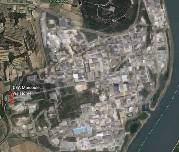
Image source: Reddit
Marcoule Nuclear Site is situated in the scenic Rhône River valley in southern France and has been a hub for diverse nuclear activities, encompassing research, development, and the reprocessing of nuclear fuel. This facility, due to its involvement in sensitive nuclear operations, may not be visible on Google Maps.
4. Sandy Island, Australia:
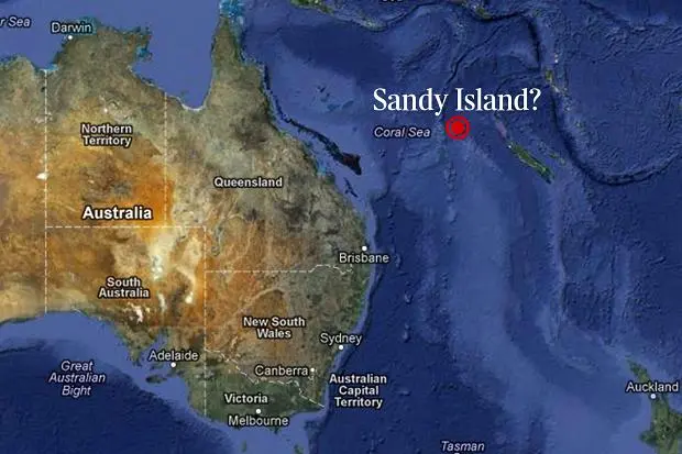
Image source: Reddit
In 2012, a scientific expedition debunked the existence of Sandy Island, revealing that it was a cartographic error that had persisted for more than a century. Despite being listed on maps and charts, the island was claimed to be nonexistent. If you search for Sandy Island on Google Maps now, you should not find a physical landmass at the reported coordinates.
5. North Korea's Western shore:
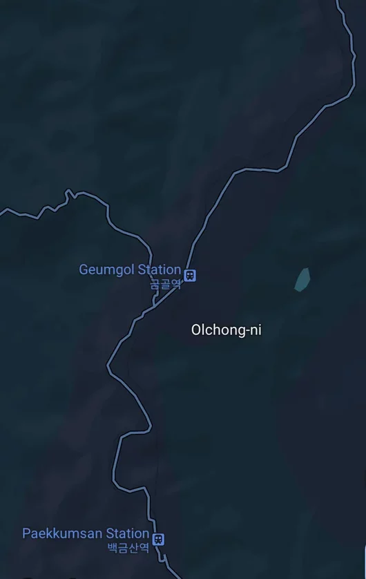
Image source: Reddit
North Korea's western shore on public maps is often limited due to the secretive nature of the country (on street view) and strict control over the release of geographical data. North Korea is known for its closed-off policies, and the government exercises tight control over what information is made available to the public.
6. Moruroa Island, French Polynesia:
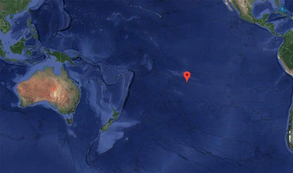
Image source: Reddit
Moruroa, also known as Mururoa, is an atoll located in the South Pacific Ocean and is a part of French Polynesia. It gained international attention due to nuclear testing conducted by France. The atoll served as a site for French nuclear tests between 1966 and 1996.
7. The Yard of Orange Trees, Spain:
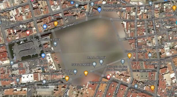
Image source: Reddit
The "Yard of Orange Trees" ("Patio de los Naranjos" in Spanish) is a historic site located within the premises of the Great Mosque of Cordoba (Mezquita-Catedral) in Cordoba, Spain. It was known for its Christian influence. Nobody really knows why when you search it on Google Maps, it is completely buried!
8. Area 51, Nevada, USA:
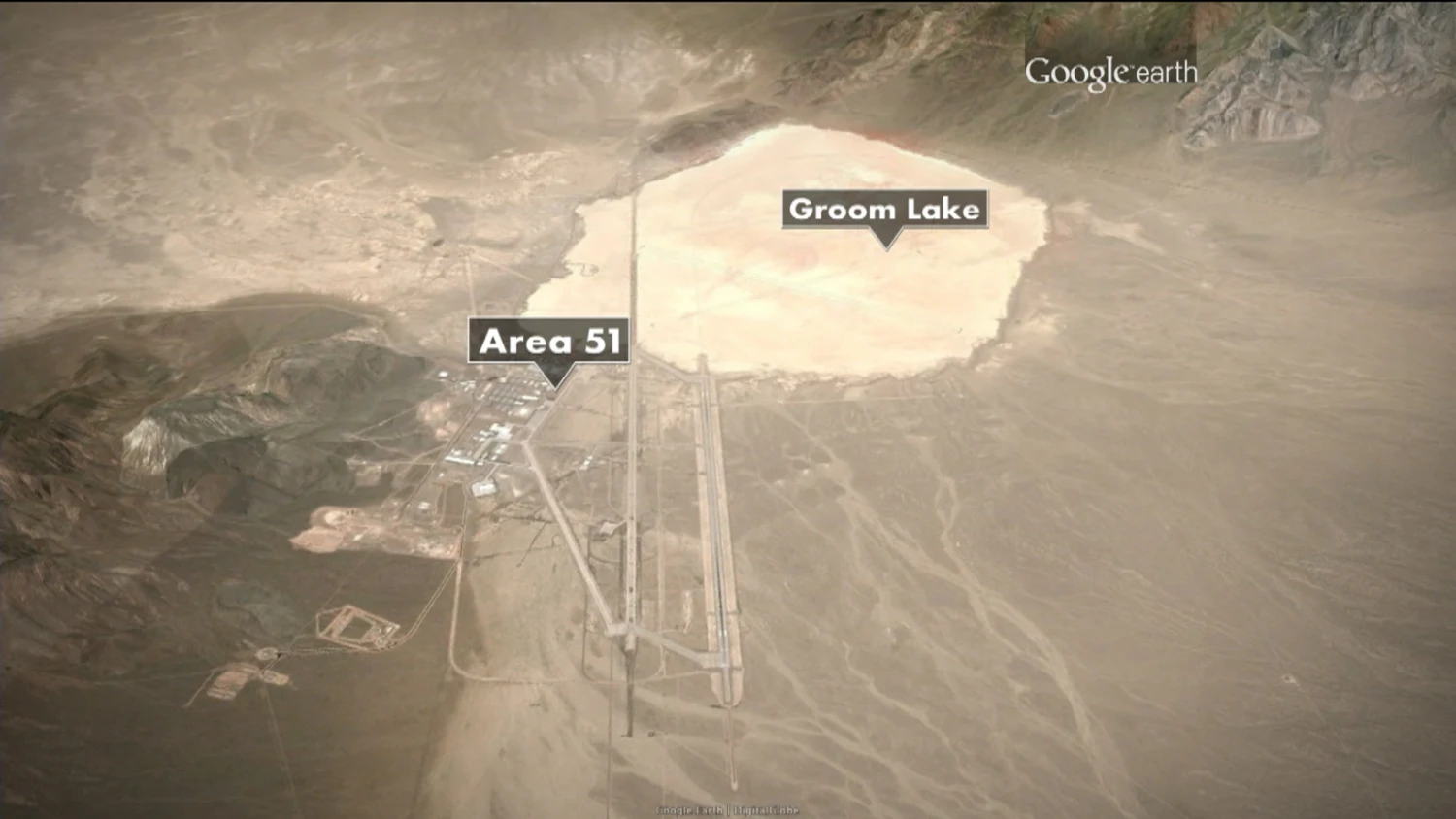
Image source: Reddit
Area 51 is a highly classified U.S. military facility located in the southern part of Nevada, USA. It is situated within the United States Air Force's (USAF) vast Nevada Test and Training Range. When searching for Area 51 on popular mapping services like Google Maps, you may find that details of the base, such as the runway layout and certain buildings, are totally obscured.
9. Faroe Islands, Denmark:
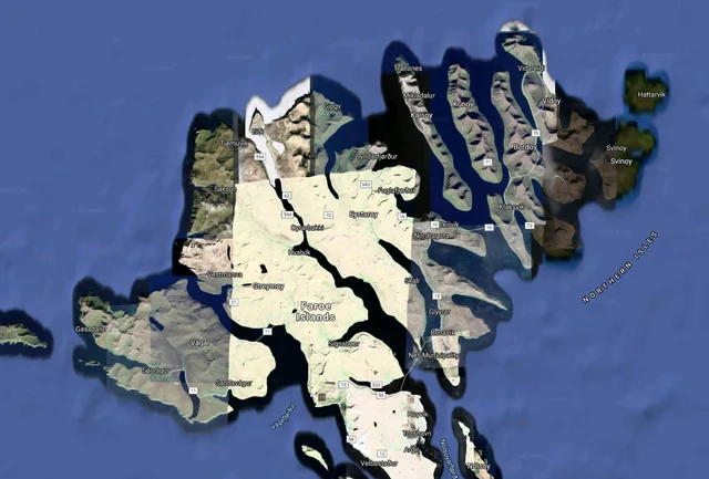
Image source: Reddit
The Faroe Islands are an autonomous territory within the Kingdom of Denmark. Located in the North Atlantic Ocean, the Faroe Islands are known for their stunning landscapes, including steep cliffs, green valleys, and picturesque villages. Strangely, parts of the islands are covered from view!
10. South Korea's Western shore:
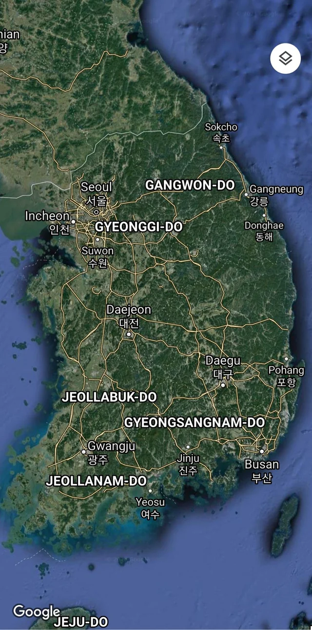
Image source: Reddit
When you search South Korea, you'll find that large parts of the Western shore cannot be seen on the map and they have purposefully been blurred so that people can see them! Popular locations along the western coast include major cities like Incheon and Gunsan, as well as islands such as Baengnyeongdo.
11. High-Frequency Active Auroral Research Program, Alaska:
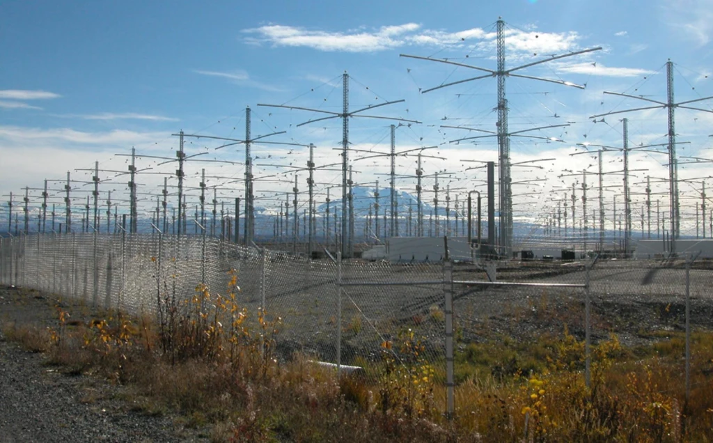
Image source: Reddit
The High-Frequency Active Auroral Research Program (HAARP) is an ionospheric research program located near Gakona, Alaska. Operated by the U.S. Air Force, the U.S. HAARP is designed to study the ionosphere and its potential applications in communication and surveillance.
12. Fort Eben-Emael, Belgium:
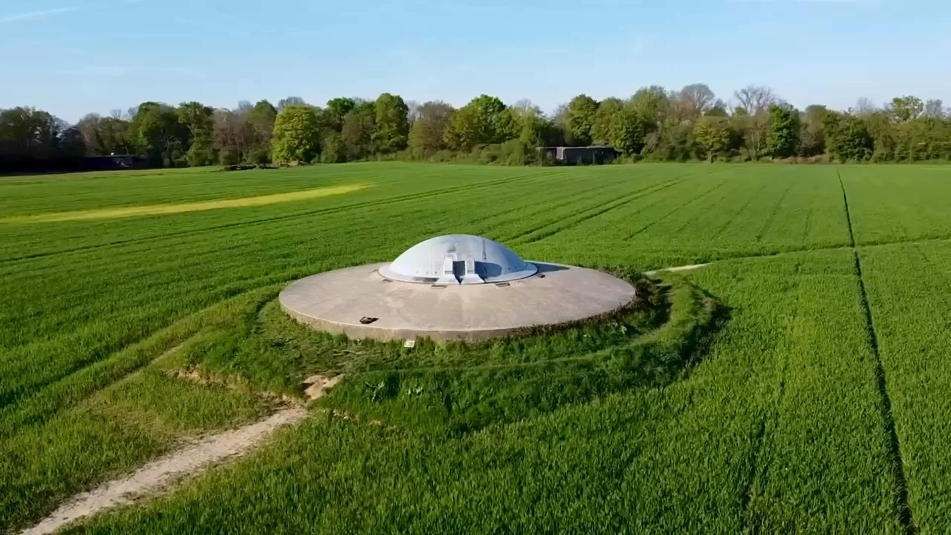
Image source: Reddit
When searching for Fort Eben-Emael on mapping services like Google Maps, you can't see its location and the layout of the fortress. The fort was designed to be an impregnable defensive position, but it was famously captured by German forces during the early stages of the invasion of Belgium in May 1940.
13. Wellington, Florida:
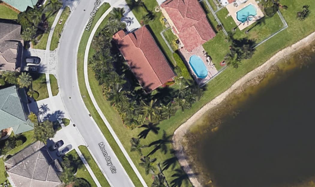
Image source: Reddit
Wellington is a village located in Palm Beach County, Florida, United States. A man had left his house in 2012 and ever returned, he was missing for many years until several years later in 2019 a man browsing Google Maps spotted his car in the lake. His body was then recovered from the car!
14. La Hague Nuclear Plant, France:
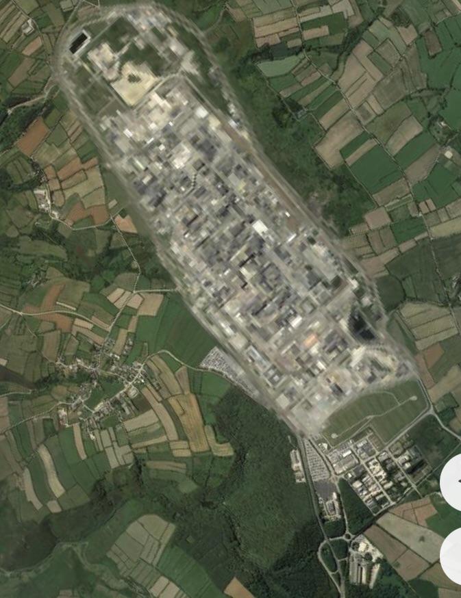
Image source: Reddit
La Hague is known for hosting the La Hague nuclear reprocessing plant, officially known as Orano La Hague. This facility is located in the La Hague peninsula, near Cherbourg in Normandy, France. The La Hague site is dedicated to the treatment and recycling of nuclear fuel, and it plays a crucial role in France's nuclear energy program.
15. Keowee Dam, South Carolina:
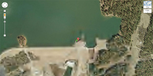
Image source: Reddit
Keowee Dam was constructed primarily for hydroelectric power generation and flood control. Built in the 1960s by Duke Energy, Keowee Dam is a concrete gravity dam that plays a crucial role in harnessing the energy potential of the Keowee River. But, if you try to find it on Google Maps, you won't be able to find it.
16. Tantauco National Park, Chile:
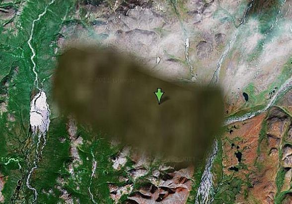
Image source: Reddit
If you type the location on Google Maps, you can find it by a marker only. You can't see anything within the location. The park is a haven for conservation, protecting a significant portion of the globally rare Valdivian temperate rainforest. This type of rainforest is known for its unique flora and fauna, making Tantauco a crucial area for ecological preservation.
17. Skull and Bones Tomb, Yale University, USA:
Image source: Reddit
Skull and Bones is one of the oldest and most secretive undergraduate secret societies at Yale University. It was founded in 1832 and has counted numerous influential individuals among its members, including former U.S. presidents and other notable figures.
18. Amchitka Island, Alaska:
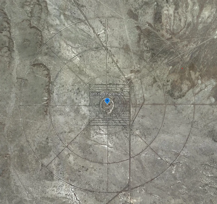
Image source: Reddit
In the mid-20th century, the island became a testing ground for large underground nuclear bombs, with the 1971 "Cannikin" test being the most powerful in U.S. history. This nuclear testing raised concerns about the environment and the well-being of the wildlife. Today, scientists and environmentalists are actively monitoring and addressing any lingering effects on the island's ecosystem.
19. Minami Torishima Airport, Japan:
Image source: Reddit
Minami Torishima Airport, located on Minami Torishima (also known as Marcus Island), is a small airport serving the island, which is part of Japan's Ogasawara Archipelago. Here's an overview: The airport on Minami Torishima primarily consists of a simple airfield with a runway suitable for smaller aircraft. But, it's also been known as a research facility!
20. RAF Menwith Hill, United Kingdom:
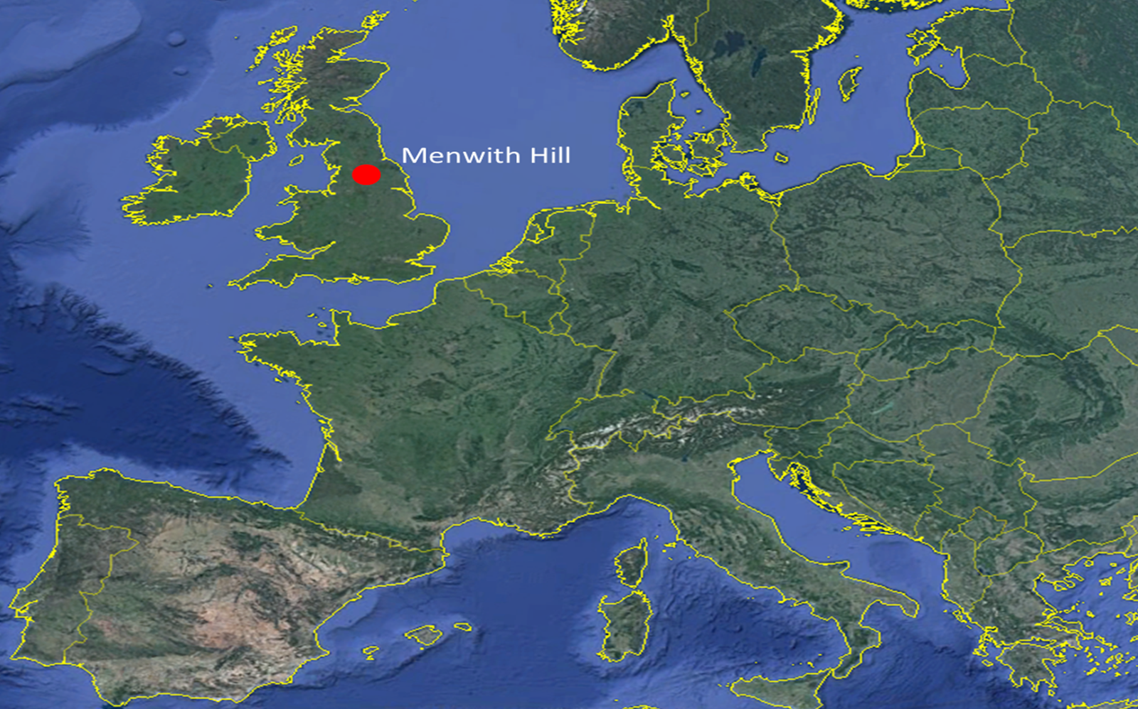
Image source: Reddit
RAF Menwith Hill, England, stands as a secret and crucial hub in the world of signals intelligence (SIGINT). Operated by the United States under the oversight of the National Security Agency (NSA), this Royal Air Force station is renowned for its role in electronic surveillance and monitoring.
21. Butyn, Russia:
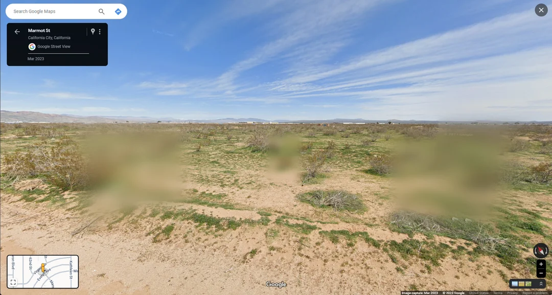
Image source: Reddit
Butyn is a small village located in Russia, and while it might not be widely recognized on a global scale, it holds significance for the local community and offers a glimpse into the rural life of the country. For unknown reasons, it remains a mystery that can't be seen on Google Maps!
22. Seattle Mayor's House, Washington:
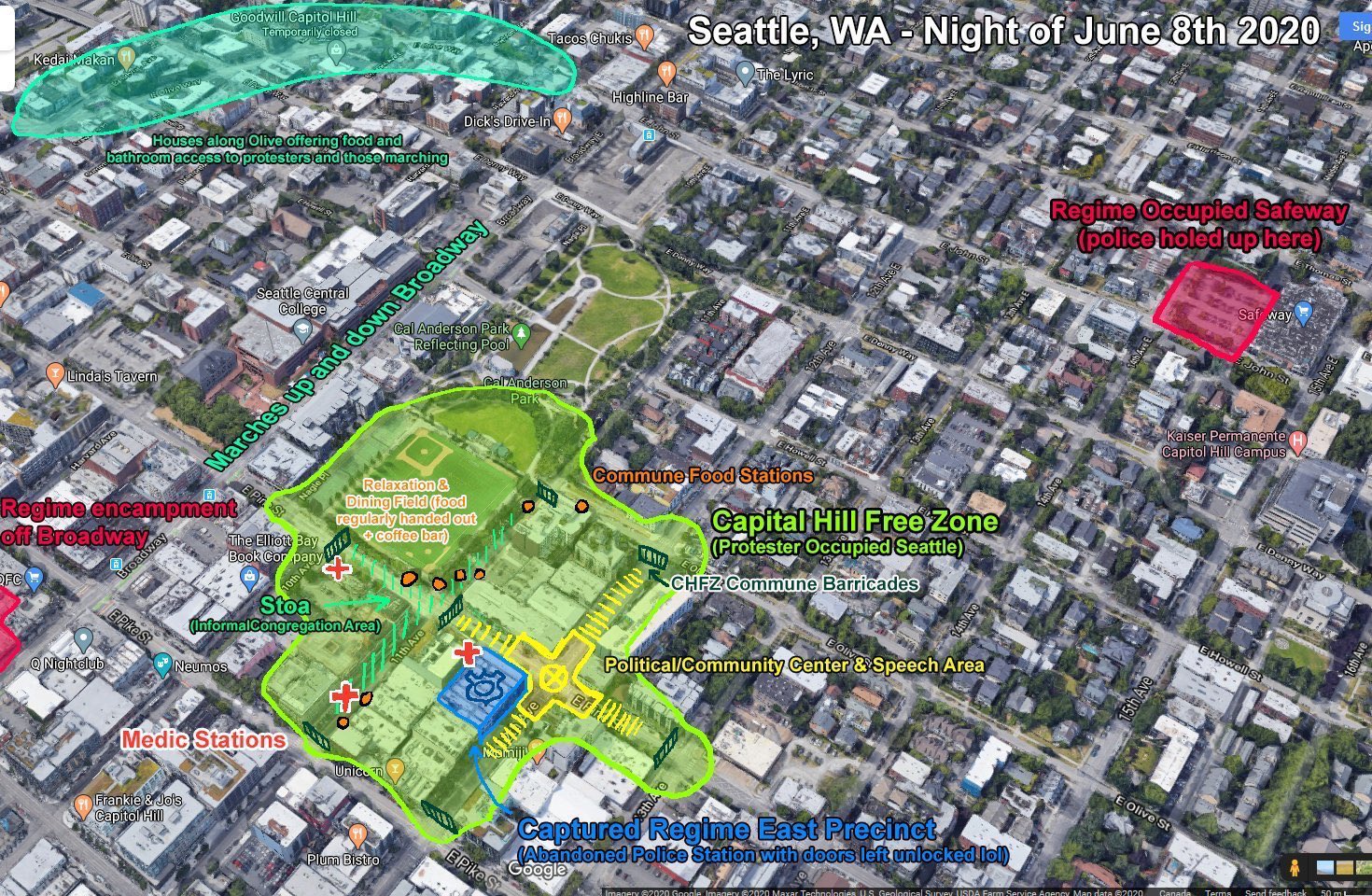
Image source: Reddit
On June 28, 2020, demonstrators rallied and marched to the residence of Seattle Mayor Jenny Durkan. Due to Mayor Durkan's past role as a district attorney, her home is intentionally obscured on Google Maps Street View. This privacy measure reflects the sensitivity around public figures' personal spaces and addresses concerns related to security and safety.
23. Cattenom Nuclear Power Plant, France:
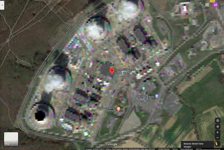
Image source: Reddit
The Cattenom Nuclear Power Plant in France is a huge generator that produces a lot of the country's electricity. It started operating in the '80s and uses technology with nuclear reactions to make power. While it helps keep France's environmental impact lower, people worry about how it deals with nuclear waste.
24. The Oval Office, Washington, D.C., USA:
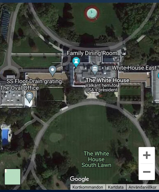
Image source: Reddit
The Oval Office, located in the West Wing of the White House in Washington, D.C., is the official office of the President of the United States. It holds immense historical and symbolic significance as the primary workplace for the U.S. President - which is why if you search it on Google Maps, it is covered with a white mark.
25. Svalbard Global Seed Vault, Norway:
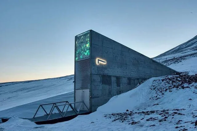
Image source: Reddit
The Seed Vault serves as a global backup for the world's seed banks, preserving a vast collection of seeds from various plants critical for food production. The facility consists of a series of tunnels and chambers that can store up to 4.5 million seed samples, each containing several hundred seeds and it's kept very secretive!
26. Nellis Air Force Base, Nevada, USA:
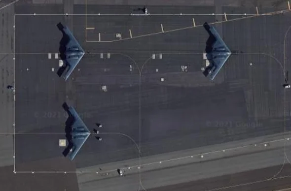
Image source: Reddit
Nellis Air Force Base serves as a hub for testing and developing cutting-edge aviation technologies, Nellis is intricately linked to the Nevada Test and Training Range, one of the world's largest military training areas. The base is home to Top Gun – the U.S. Air Force Weapons School – where top-tier aviators undergo advanced training.
27. Vladimir Putin's Residence, Russia:
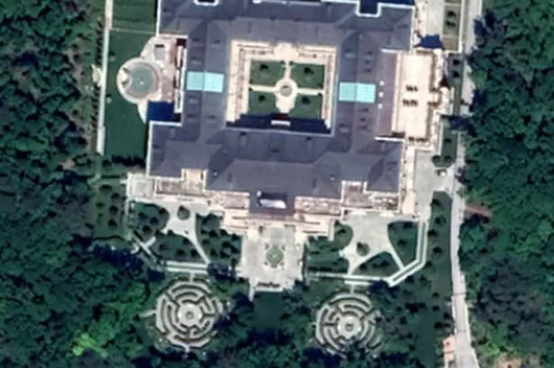
Image source: Reddit
The specific details of Vladimir Putin's residence in Russia are not publicly available due to security and privacy concerns. Information about the residences of political leaders, especially those of heads of state, is often kept confidential. Particularly given the controversy of Putin.
28. Kos International Airport, Greece:
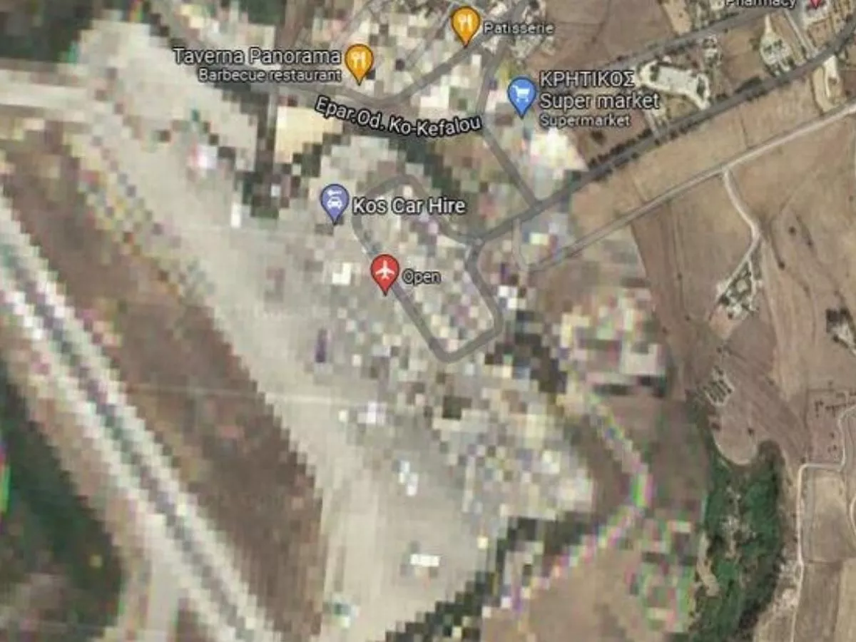
Image source: Reddit
Kos International Airport is situated near the town of Andimachia, approximately 24 kilometers southwest of the capital city, Kos Town. The airport serves as a gateway for travelers arriving on the island. It remains unknown why the airport has been chosen to remain unseen on Google Maps.
29. A neighborhood located in Taipei, Taiwan:
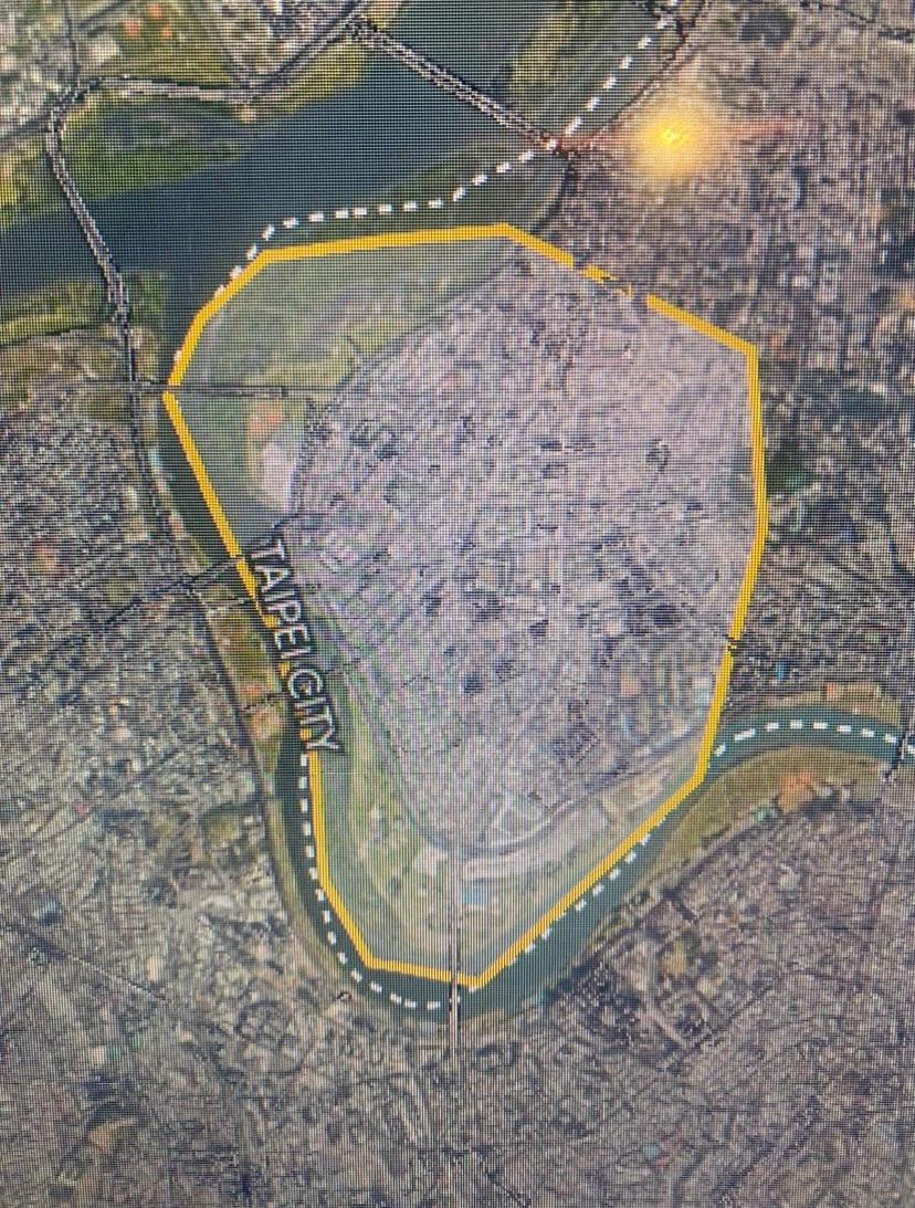
Image source: Reddit
Da'an District stands out as a prominent neighborhood in Taipei, Taiwan, characterized by its unique blend of residential and commercial spaces. Located in the heart of the city, Da'an is home to the prestigious National Taiwan University (NTU), contributing to its youthful and vibrant atmosphere - but it can't be seen on the map!
30. Guantanamo Bay Naval Base, Cuba:
Image source: Reddit
Guantanamo Bay serves as a U.S. naval base, but it gained international attention primarily due to the establishment of a detention facility, often referred to as Guantanamo or Gitmo. After the September 11, 2001 attacks, Guantanamo Bay became a key location for detaining individuals suspected of having ties to terror.
31. Maelbeek/Maalbeek Metro Station, Brussels, Belgium:
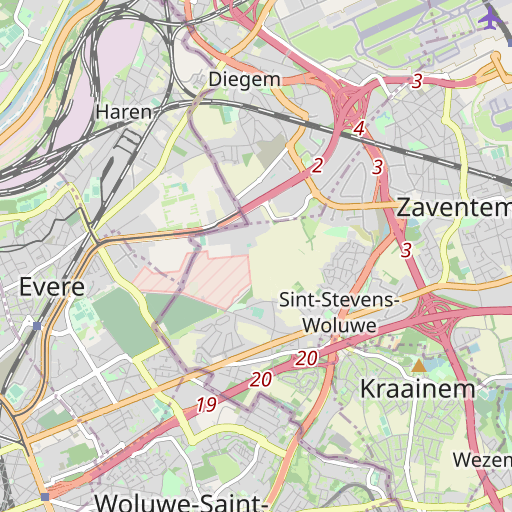
Image source: Reddit
Maelbeek/Maalbeek Metro Station is a notable underground railway station located in the heart of Brussels, Belgium's capital city. However, its story takes a poignant twist back to 2016 when it became a symbol of resilience in the face of tragedy during the Brussels bombings.
32. Fukushima Daiichi Nuclear Power Plant, Japan:
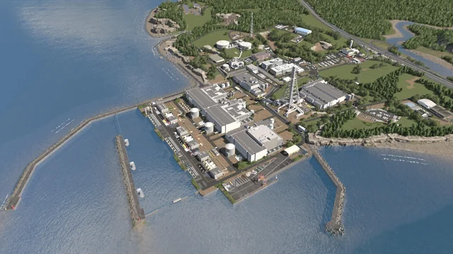
Image source: Reddit
The Fukushima Daiichi Nuclear Power Plant became known for the catastrophe following the devastating events of March 11, 2011. Struck by a powerful earthquake and an ensuing tsunami, the facility experienced a series of nuclear meltdowns, leading to the release of radioactive materials!
33. Fort Knox, Kentucky, USA:
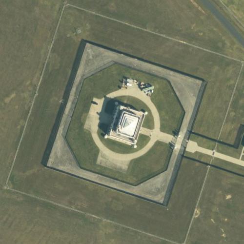
Image source: Reddit
Another hidden location is Fort Knox, which is home to the U.S. Army Armor Center and the U.S. Army Armor School. The Armor School is responsible for training soldiers in armor and cavalry operations. The installation has played a crucial role in the development and training of armored and tank units within the U.S. military.
34. North Brother Island, New York, USA:
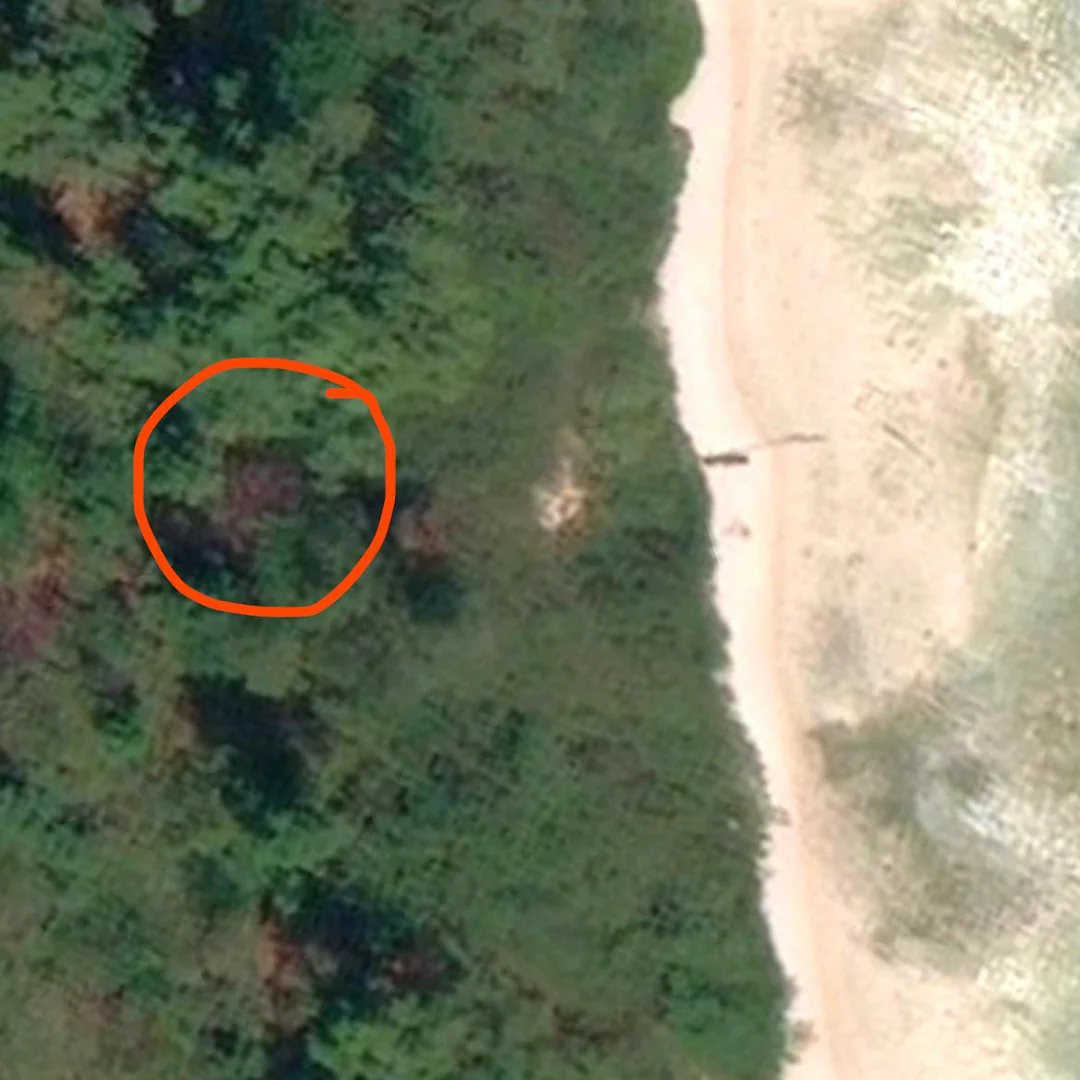
Image source: Reddit
North Brother Island, a 20-acre island between the Bronx and Riker's Island in New York, has a rich but haunting history. Once home to Riverside Hospital, the island served as a quarantine facility for contagious diseases in the late 19th and early 20th centuries. Most notably, it housed Mary Mallon, known as "Typhoid Mary," who was a carrier of typhoid fever.
35. Alcatraz Island, California, USA:
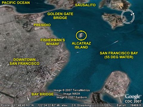
Image source: Reddit
In 1969, a group of Native American activists occupied Alcatraz Island, advocating for Native American rights. While the occupation eventually ended, it drew attention to the broader issues facing indigenous communities in the United States. On maps, specific details might be limited, as the island is managed by the National Park Service, and certain areas may not be fully visible for conservation and security reasons.
36. Mystery site in the Siberian tundra, Russia:
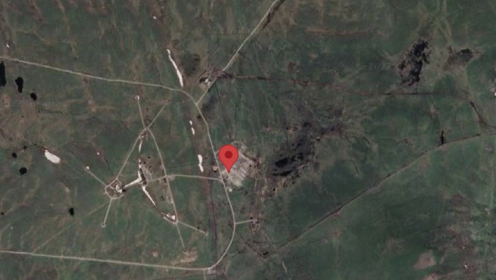
Image source: Reddit
The reason behind the intentional blurring of this specific location in the Siberian tundra, near Egvekinot, Russia, remains unclear! This mysterious censorship adds an air of intrigue to the area, situated as a neighbor to Alaska across the Bering Strait. The secrecy surrounding this blurred site raises a lot of questions.
37. Stockton-on-Tees, England:
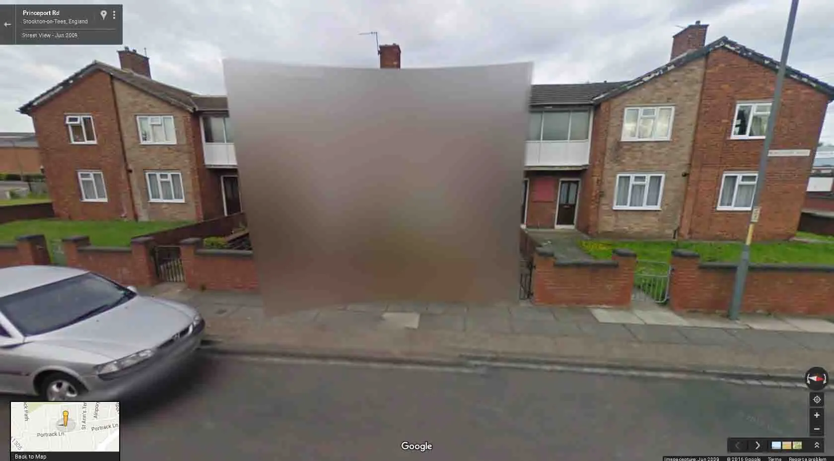
Image source: Reddit
Stockton-on-Tees, in North East England, started as a buzzing market town in the 13th century and then kicked it up a notch during the Industrial Revolution. They even claim fame for having the world's first public railway in 1825! For some unknown reason, it has been covered on Google Maps.
38. Kalymnos Island National Airport, Greece:
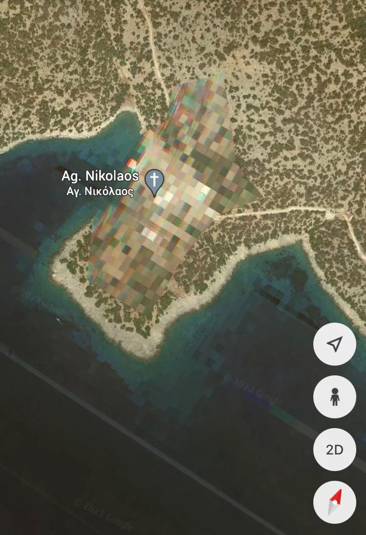
Image source: Reddit
When you look for Kalymnos Island National Airport on Google Maps, the area is totally pixelated! It's been completely blurred out. Kalymnos Island National Airport stands as a crucial transport hub on the scenic Greek island of Kalymnos, nestled in the southeastern Aegean Sea.
39. Ramstein Air Base, Germany:
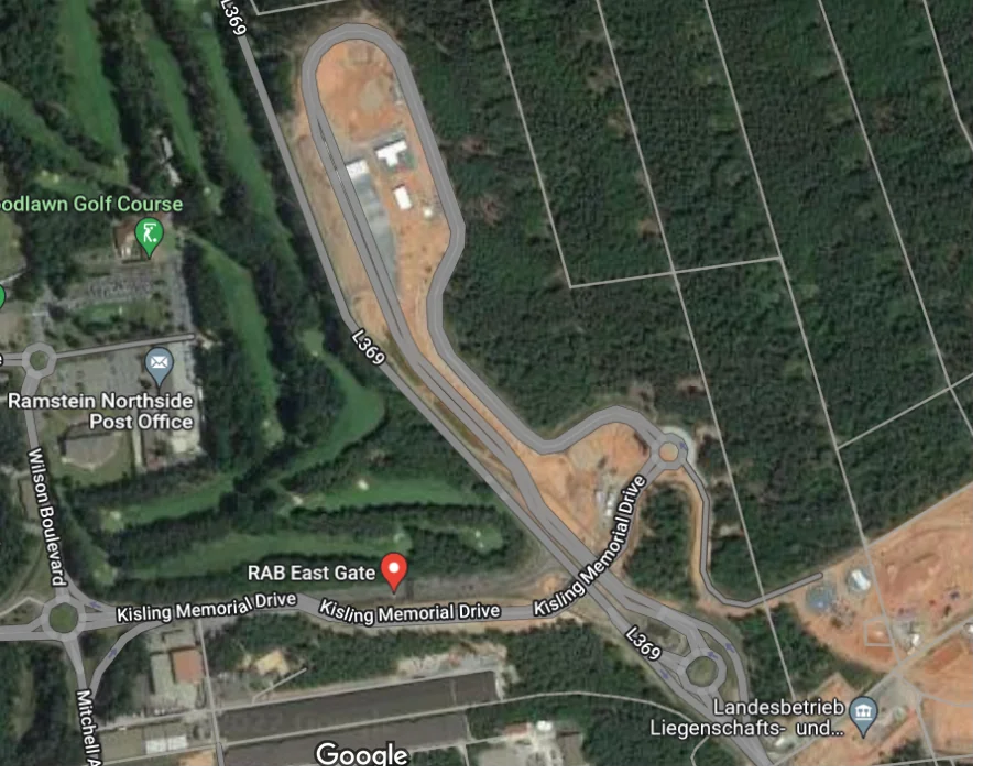
Image source: Reddit
Ramstein Air Base, situated near the town of Ramstein-Miesenbach in the German state of Rhineland-Palatinate, holds significant strategic importance as a key installation for the United States Air Force (USAF) in Europe. The secret nature of the base means that it can't be seen on Google Maps.
40. U.S. Strategic Command, Nebraska, USA:
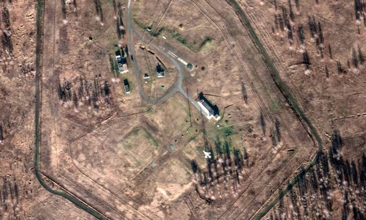
Image source: Reddit
United States Strategic Command (USSTRATCOM) is one of the eleven unified combatant commands of the United States Department of Defense. It is responsible for the global command and control of U.S. strategic forces, including nuclear forces, missile defense, and space operations - making it one of the most secretive places!
41. Huis Ten Bosch Palace, Netherlands:
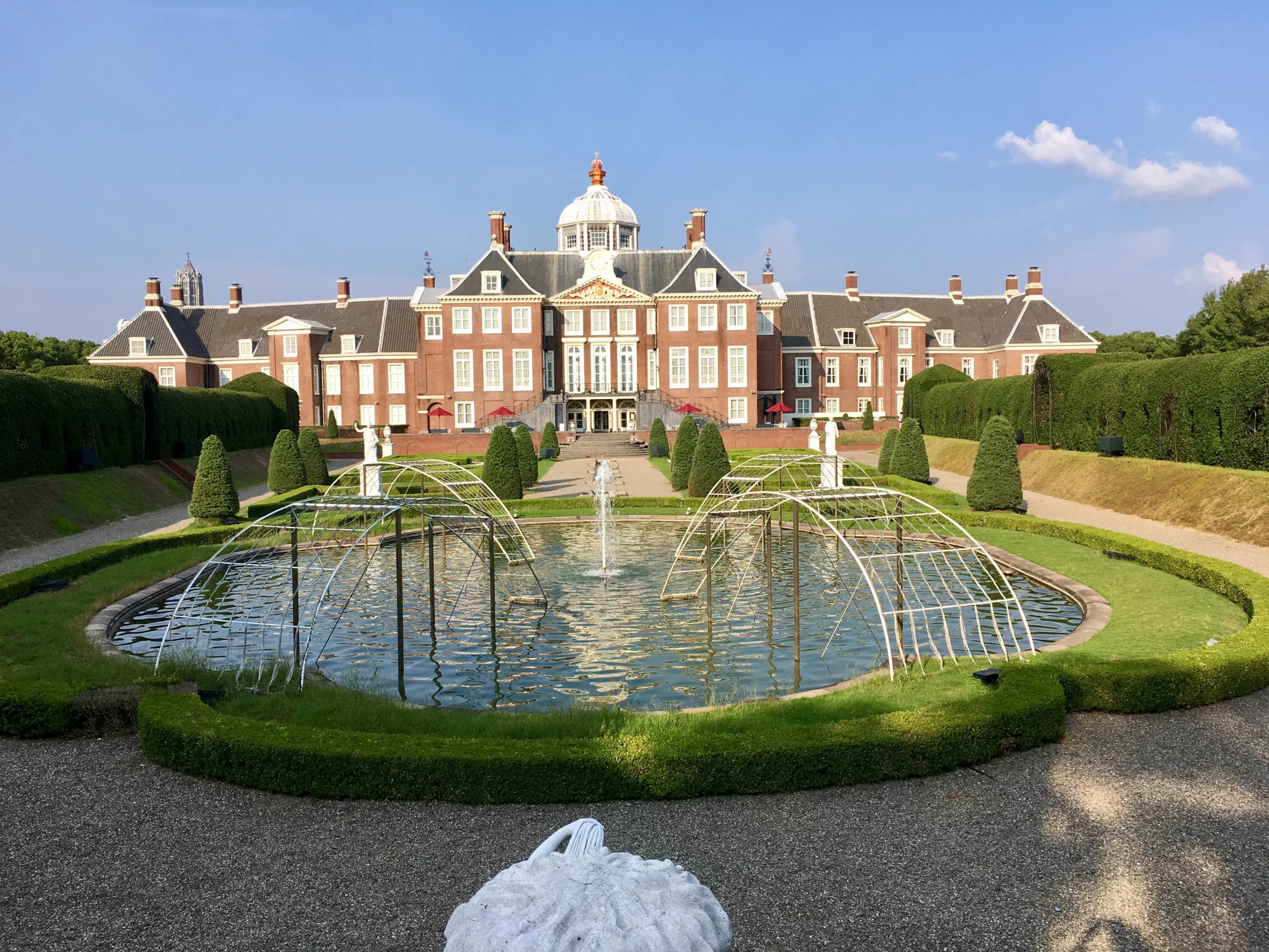
Image source: Reddit
The Koninklijk Paleis Amsterdam, known as the Royal Palace of Amsterdam in the Netherlands, is among several locations intentionally blurred on Google Maps, maintaining a trend associated with the Dutch royal family. This list includes the Royal Stables and another royal residence named Huis ten Bosch!
42. Demilitarized Zone (DMZ) between North and South Korea:
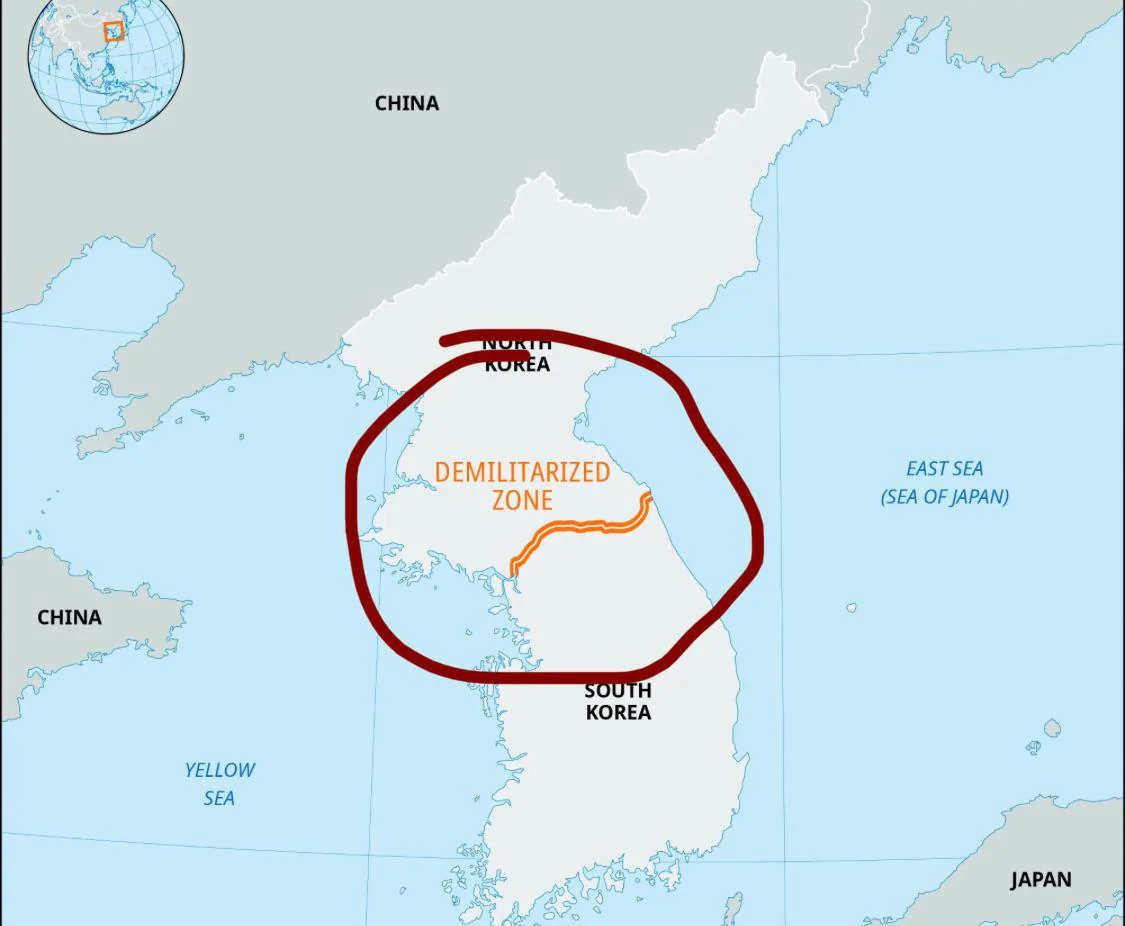
Image source: Reddit
The Demilitarized Zone (DMZ) between North and South Korea stands as a testament to the complex and unresolved history of the Korean Peninsula. Established in 1953 as part of the armistice that halted the Korean War, this 250-kilometer strip of land serves as a buffer zone, yet it is one of the most heavily fortified borders globally.
43. Tantallon Castle, Scotland:
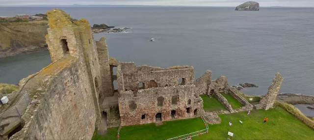
Image source: Reddit
Built in the mid-14th century by William Douglas, the 1st Earl of Douglas, this imposing stronghold has witnessed numerous conflicts, including sieges and battles during the Wars of Scottish Independence. The area on Google Maps is not available to view, maybe due to its complex history.
44. Cheyenne Mountain Complex, Colorado, USA:
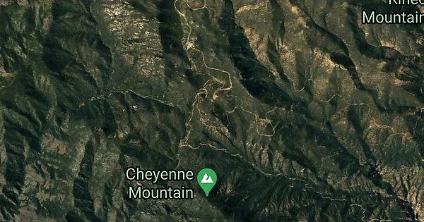
Image source: Reddit
The Cheyenne Mountain Complex in Colorado is a super-secure fortress built into a mountain. It was made during the Cold War, a time of tension between the United States and the Soviet Union. Inside this complex, there's a top-secret command center where military experts keep an eye on the skies for any potential threats, especially missile attacks!
45. Pine Gap, Australia:
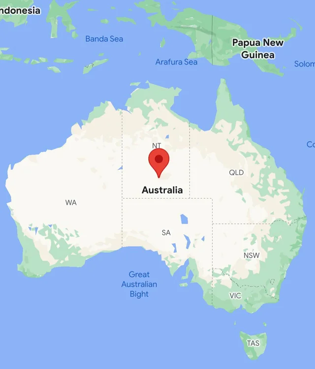
Image source: Reddit
Pine Gap, located in the vast Australian Outback near Alice Springs, is a secretive facility (hidden on the maps) with a significant role in global intelligence and defense. Although surrounded by an air of mystery, it is known to be jointly operated by the United States and Australia. Officially, it is called the Joint Defence Facility Pine Gap.
46. Zzyzx, California, USA:
Image source: Reddit
Zzyzx, found in the Mojave Desert of California was established at the Zzyzx Mineral Springs and Health Resort around a natural spring, touting the mineral-rich water for its supposed health benefits. However, legal issues arose in the 1970s when the federal government determined that Springer had unlawfully claimed the land and it was subsequently closed down the health resort in 1974.
47. Kangtega, Nepal:
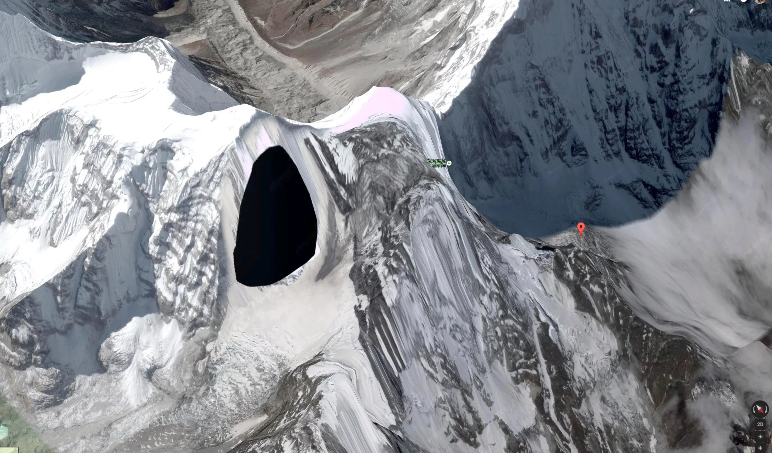
Image source: Reddit
Kangtega, also known as The Snow Saddle, is a majestic mountain located in the Himalayas of Nepal. It's one of the highest peaks in the area, and for some reason, it cannot be properly seen on Google Maps, it's been covered by a black mark, whether this is purposeful or some kind of mistake remains unclear!
48. Faslane Naval Base, Scotland:
Image source: Reddit
Faslane serves as the home of the United Kingdom's strategic nuclear deterrent, hosting the Royal Navy's fleet of Vanguard-class ballistic missile submarines. These submarines are armed with Trident II D5 nuclear missiles and form a crucial component of the UK's national defense strategy. The top-class nature means it's been hidden from the map!
49. Google Zurich Office Rooftop, Switzerland:

Image source: Reddit
The Google Zurich office rooftop, like many corporate spaces, is intentionally obscured on maps for privacy, security, and competitive reasons. Tech companies, including Google, implement measures to protect sensitive information and maintain the privacy of their employees and the layout of their offices.
50. Mezhgorye, Russia:
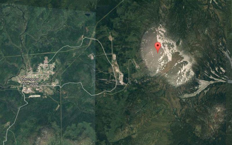 Image source: Reddit
Mezhgorye is a closed town in the Republic of Bashkortostan, Russia, and is known for its secretive and restricted nature. Being a closed town means that access to Mezhgorye is highly restricted, and information about the town is limited. Mezhgorye is associated with the Russian military and is rumored to house a significant military facility.